


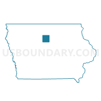
CLARION Voting District, Wright County, Iowa
About
Outline

Summary
| Unique Area Identifier | 583850 |
| Name | CLARION Voting District |
| County | Wright County |
| State | Iowa |
| Area (square miles) | 3.26 |
| Land Area (square miles) | 3.26 |
| Water Area (square miles) | 0.00 |
| % of Land Area | 100.00 |
| % of Water Area | 0.00 |
| Latitude of the Internal Point | 42.73221320 |
| Longtitude of the Internal Point | -93.72935950 |
Maps

Graphs
Select a template below for downloading or customizing gragh for CLARION Voting District, Wright County, Iowa


Neighbors
Neighoring Voting District (by Name) Neighboring Voting District on the Map
- DAYTON TWP W/O CLARION Voting District, Wright County, IA
- GRANT TWP W/O CLARION Voting District, Wright County, IA
- LAKE TWP W/O CLARION Voting District, Wright County, IA
- LINCOLN TWP W/O CLARION Voting District, Wright County, IA
Top 10 Neighboring County Subdivision (by Population) Neighboring County Subdivision on the Map
- Grant township, Wright County, IA (1,597)
- Lincoln township, Wright County, IA (1,386)
- Dayton township, Wright County, IA (358)
- Lake township, Wright County, IA (326)